| Spielplatz Weather Data | |||
|---|---|---|---|
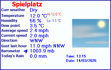
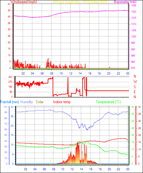
| LAST READING AT TIME: 04:00 DATE: 25 May 2026, time of next update: 04:15 | |||
| Current Weather | Night time/Dry | Current Temperature | 14.4°C (58.0°F), Apparent temp 15.3°C |
| Maximum Temperature (since midnight) | 18.4°C at: 00:00 | Minimum Temperature (since midnight) | 14.4°C at: 03:57 |
| Average windspeed (ten minute) | 0.0 mph | Wind Direction (ten minute) | SW (225°) |
| Windchill Temperature | 14.4°C | Maximum Gust (last hour) | 0.0 mph at: 04:00 |
| Maximum Gust (since midnight) | 0.0 mph at: 11:32 | Maximum 1 minute average (since midnight) | 0.0 mph at: 12:46 |
| Rainfall (last hour) | 0.0 mm | Rainfall (since midnight) | 0.0 mm (0.00 in.)--- |
| Rainfall This month | 10.4 mm (0.41 in.) | Rainfall To date this year | 195.8 mm (7.71 in.) |
| Maximum rain per minute (last hour) | 0.0 mm/min | Maximum rain per hour (last 6 hours) | 0.0 mm/hour |
| Yesterdays rainfall | 0.0 mm | DewPoint | 12.8°C (Wet Bulb :13.5°C ) |
| Humidity | 90 %, Humidex 17.1°C | Barometer corrected to msl | 1028.3 mb |
| Pressure change | 0.0 mb (last hour) | Trend (last hour) | STEADY |
| Pressure change (last 12 hours) | +1.2 mb | Pressure change (last 6 hours) | +0.2 mb |